


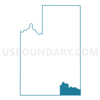
Voting District 9016, Spokane County, Washington
About
Outline

Summary
| Unique Area Identifier | 689481 |
| Name | Voting District 9016 |
| County | Spokane County |
| State | Washington |
| Area (square miles) | 66.88 |
| Land Area (square miles) | 66.88 |
| Water Area (square miles) | 0.00 |
| % of Land Area | 100.00 |
| % of Water Area | 0.00 |
| Latitude of the Internal Point | 47.30130110 |
| Longtitude of the Internal Point | -117.18894110 |
Maps

Graphs
Select a template below for downloading or customizing gragh for Voting District 9016, Spokane County, Washington


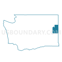
Neighbors
Neighoring Voting District (by Name) Neighboring Voting District on the Map
- Voting District 9017, Spokane County, WA
- Voting District 9018, Spokane County, WA
- Voting District 9400, Spokane County, WA
- Voting District 9600, Spokane County, WA
- Oakesdale Voting District, Whitman County, WA
- Plummer Voting District, Benewah County, ID
- Rosalia Voting District, Whitman County, WA
- Tekoa Voting District, Whitman County, WA
Top 10 Neighboring County Subdivision (by Population) Neighboring County Subdivision on the Map
- Rockford CCD, Spokane County, WA (3,195)
- Plummer CCD, Benewah County, ID (1,766)
- Rosalia CCD, Whitman County, WA (1,100)
- Tekoa CCD, Whitman County, WA (935)
Top 10 Neighboring Place (by Population) Neighboring Place on the Map
Top 10 Neighboring Unified School District (by Population) Neighboring Unified School District on the Map
- Liberty School District, WA (4,440)
- Plummer-Worley Joint School District 44, ID (3,831)
- Rosalia School District, WA (1,089)
- Tekoa School District, WA (943)
- Oakesdale School District, WA (837)
Top 10 Neighboring State Legislative District Lower Chamber (by Population) Neighboring State Legislative District Lower Chamber on the Map
Top 10 Neighboring State Legislative District Upper Chamber (by Population) Neighboring State Legislative District Upper Chamber on the Map
Top 10 Neighboring 111th Congressional District (by Population) Neighboring 111th Congressional District on the Map
Top 10 Neighboring Census Tract (by Population) Neighboring Census Tract on the Map
- Census Tract 9400, Benewah County, ID (4,536)
- Census Tract 9, Whitman County, WA (3,733)
- Census Tract 143, Spokane County, WA (3,195)
Top 10 Neighboring 5-Digit ZIP Code Tabulation Area (by Population) Neighboring 5-Digit ZIP Code Tabulation Area on the Map
- 83851, ID (1,691)
- 99031, WA (1,137)
- 99170, WA (1,072)
- 99012, WA (1,064)
- 99033, WA (895)
- 99158, WA (603)
- 99018, WA (282)
- 99039, WA (87)